Posted by: turtles06 | October 13, 2013

The Journey Complete

Post Killer big berg pool (1024x678)

When I began this blog back in February 2012, it was with the goal of chronicling our preparations for this extraordinary trip, and then documenting the adventure itself.  Along the way, I also hoped to provide useful information for others contemplating this journey, and I hope that I’ve succeeded in doing so.  (To read the posts in chronologic order, please of course go back to the beginning.  And to enlarge a photo, just click on it.)

I also mentioned in that very first journal entry that our trip had been made possible by the generosity of my then-89-year-old aunt.  Not only her financial generosity, but also her intangible gift of the love of travel and adventure.

Sadly, a little more than a month after MP and I returned from Antarctica, my aunt passed away; she was nearly 91.  She had a great life, and was a blessing in mine.  One of the last things I was able to share with her were some of my photos from Antarctica.  I am so very grateful that I had that opportunity.

I dedicate this journal to my aunt.  She helped make this happen.  No words can express my gratitude.

(photo by turtles06)

Posted by: turtles06 | October 13, 2013

Days Twelve and Thirteen — Fin del Mundo, Fin del Journey

On Thursday, February 7, we awoke aboard the Explorer, docked in Ushuaia, and were delightedly surprised when we pulled back the curtains to see the Celebrity Infinity docked right across from us.

Feb 7 out cabin window (1024x678)

And that’s because, literally the day before leaving home for Buenos Aires, we’d booked an October transatlantic on the Infinity.  So here we were, on a ship at Fin del Mundo — the End of the World — seeing the very next ship we’d be on, months later.  That seemed pretty extraordinary to us.   (Not long after returning from South America, catching up on TV we’d recorded while away, we were watching an episode of Top Chef, only to find it taking place on, you guessed it, the Infinity.  We were certainly getting a message about that ship!)

After breakfast, we left the Explorer for the last time — goodbyes all around to the wonderful staff and crew.

Feb 7 leaving the Explorer (1024x678)

We were taken by bus to the Maritime Museum, housed in the former Prison of Ushuaia, where we had time on our own to explore.

Feb 7 The Prison (1024x678)

Feb 7 Maritime Museum sign (1024x682)

The Museum wing of the prison had been painted and fixed up, but the other wing gave us a much more realistic sense of the prisoners’ grim living conditions.

Feb 7 prison cell (1024x678)

Feb 7 prison guard (1024x678)

Feb 7 the prison 2 (1024x678)

Feb 7 the prison 3 (1024x678)

Then it was back to the port area, where we were able to walk around, shop, and take photos.

Feb 7 Puerto Ushuaia (1024x678)

Feb 7 Ushuaia (1024x678)

Feb 7 Infinity & Explorer (1024x468)

Feb 7 Fin del Mundo sign (1024x713)

Feb 7 Ush Port (1024x678)

Fortunately, plenty of shops were open, and I finally succeeded in finding the only souvenir I wanted to buy:

Feb 7 FIn del Mundo cap (887x1024)

Then it was off to the nearby Hotel Albatros, while we killed time had some refreshments until it was time to head for the airport and our LAN charter flight back to Buenos Aires.

Feb 7 Albatross Hotel (1024x574)

Getting our boarding passes at the airport was absurdly difficult.  We were instructed to wait in lines divided into two groups alphabetically by last name — but for some reason, our line never moved.  Ever.  It got to the point that we thought the plane would leave without half the alphabet.  Finally, the other letters had been cleared out, and half of us still on line were instructed to line up where the other line used to be.   But the gate agents still had to go over to the other desk where the boarding passes were, so it was still very slow going.

When MP finally got to the head of our line, and got her boarding pass, it showed her once again in a middle seat, even though she had spoken with Lindblad staff on the Explorer and been assured they had taken care of getting her an aisle seat.  Nope.  Fortunately, the gate agent was able to get her one.

We were all exhausted, and used the four-hour flight for some much needed down time.  We arrived in BA around 4:30 PM.  We’d landed at EZE, but at a domestic terminal that was quite some distance from the international terminal.  After retrieving our checked bags, we were instructed to follow along to international departures — outside. We walked, and walked, and walked, and walked.   It was about 90 degrees out, and of course we had all of our luggage.  Not pleasant at all.  Here’s a spot where Lindblad ought to think about having buses to take passengers over to the international terminal.

Finally, we got to where we were going, only to learn that check-in for the flights back to the U.S. did not open until 6pm.  As we all waited, word was filtering down the line that a big snowstorm was moving into the northeastern United States, where so many of us were heading.  At that point, there was nothing anyone could do of course (except worry).  Our flight, scheduled to depart at 9 PM, actually took off about half an hour early; perhaps the pilots were trying to beat the storm into Newark airport.  (Which they did, thankfully.)

As on our outward bound flight, we’d used frequent flyer miles for Business Class seats, which again were lie flat seats, and quite welcome given how exhausted we were.  MP was disappointed to learn, however, that while Malbec was on the wine list, they had none aboard!  Not even after taking off from Buenos Aires!   Once again, with the aid of pharmaceuticals, I managed to get some sleep before we landed at 6 AM on Friday, February 8, day 13 of our incredible adventure.

After we deplaned, we headed over to immigration, joining literally hundreds of other travelers who had just arrived on other overnight international flights.  Only about three or four of the dozens of immigration desks were staffed (and this was before sequestration); we waited about an hour to clear immigration.  (We’ve since wised up and joined Global Entry, which we’d never heard of before this.)

Finally, we cleared immigration, retrieved our checked bags, and headed off to pick up a rental car (no more little regional jets for us).  Not long after, the airport closed down because of the storm.   We were of course quite happy that our plane had arrived before the snow and that we’d gotten out off the airport just in time.

Our drive home was uneventful.  By the time we turned the key in our door, we’d been traveling for more than a day since we’d left the Explorer on Thursday morning.  It’s still difficult to describe what we were feeling.  We were utterly exhausted, of course, and, in some ways, the fact that we had just returned from Antarctica simply did not compute.  Antarctica? 

It was truly an extraordinary adventure, and we are so grateful to have been able to have it.

(photos by turtles06)

Posted by: turtles06 | October 12, 2013

Day Eleven — Back to South America

As it turned out, Wednesday, February 6, would be our last day at sea.   The Captain had left so much time for our return to Ushuaia that we were scheduled to dock there this evening, and not in the wee hours of Thursday morning.

I awoke early, around 5 AM, and went up to the bridge about an hour later; the sun was out, and there was a sailboat far off our starboard side, heading south, toward some pretty rough weather.  I assumed they knew that!

Drake Feb 6 sailboat sun (1024x603)

The beautiful dawn skies soon gave way to a squall, with winds blowing upwards of 50 knots.  The ship was really rolling, so much so that, during breakfast, the chairs under us actually slid.  Good thing they were strapped to the deck!

Drake Feb 6 squall (1024x678)

Drake Feb 6 (1024x575)

Drake Feb 6 waves (1024x666)

MP wasn’t feel very well, and went back to our cabin after breakfast.   In fact, very few folks were out and about.  I went up to the bridge to take photos of the wind-driven waves splashing over the bow, sometimes all the way up to the windows of the bridge.  Naturalist David Cothran said he hadn’t seen seas like this in years.  I was having a blast up on the bridge, as were several other hardy souls, but I know that we were in the minority.

Drake Feb 6 whiteout (1024x678)

Drake Feb 6 bridge (1024x678)

Drake Feb 6 from bridge (1024x623)

Drake Feb 6 waves2 (1024x565)

As afternoon approached, we entered the Beagle Channel; by now, the sun was shining, and we enjoyed a slow transit of this beautiful area, accompanied by numerous birds, our last opportunity to see albatross and shags.

Beagle Feb 6 bridge (1024x669)

Beagle Feb 6 black browed pair (1024x678)

Beagle Feb 6 shag (1024x696)

We took on the harbor pilot around 5 PM . . .

Beagle Feb 6 harbor pilot (1024x721)

Beagle Feb 6 flags (1024x673)

Beagle Feb 6 lighthouse (1024x500)

. . . and docked in Ushuaia around 8:30 PM.

Feb 6 approaching Ushuaia (1024x572)

Feb 6 Ush sign (1024x536)

Feb 6 approaching Ushuaia2 (1024x702)

Feb 6 Ush from bridge (1024x678)

It was starting to get dim out, and MP decided to say aboard while I headed into town with several others to have a short look around, take some photos, and do some souvenir shopping.   (I was on a quest to find a baseball cap that said “Fin del Mundo.”  There had to be one somewhere, right?)

Feb 6 Explorer in Ush (1024x555)

Feb 6 Ush dock (1024x543)

Feb 6 Ush welcome sign (1024x717)

As you walk off the ship and down the dock, you are greeted by some interesting  “information,” courtesy of the Argentine government:

Islas Malvinas Sign (768x1024)

Alas, most stores were closed at this late hour, and I came up empty in my baseball cap quest, although it was clear that Fin del Mundo was used to advertise just about everything.

Feb 6 Ush fin del beer (1024x753)

I took some photos and headed back to the ship.

Feb 6 Ush mileage sign (1002x1024)

Feb 6 Evita park (1024x768)

Feb 6 Evita bust (1024x768)

Feb 6 Explorer at Night (1024x752)

As I boarded the Explorer for the last time, it was hard to believe this amazing adventure was coming to an end.

Feb 6 Explorer gangway (1024x768)

(photos by turtles06)

Posted by: turtles06 | September 21, 2013

Day Ten: Return to the Drake

Tuesday, February 5, found us back in the Drake Passage, heading into 15-20 knot winds that caused a great deal of pitching, and resulted in a fairly empty dining room at breakfast.

Drake Feb 5 pitching (1024x572)

Drake Feb 5 breakfast (1024x646)

At 8 AM, we were a little north of 62° S, still within political Antarctica.  Northwest winds continued to blow, picking up in strength as we headed toward South America.  The Explorer was pitching all day as it sailed into the wind, and many folks spent a good part of the day in their cabins.  I spent a good part of the day roaming around the ship, taking pictures of the interior spaces.   I also spent a good part of the day out on the stern, watching the albatross.  This particular black browed albatross followed us for a long while.

Drake Feb 5 black browed (1024x390)

By 4:40 PM, we were nearly at 60° S, almost out of Antarctica, an invisible line we were all very sad to cross.  This amazing trip was drawing to a close.  The mood on the ship was a quiet one, the first day we’d had to simply sit and reflect on our incredible adventure.

The strong winds continued into the evening, and during dinner, we could see waves crashing over the windows in the dining room.  The day ended as it had begun, with the Explorer heading into the wind toward South America, pitching to and fro . . .

Drake Feb 5 night (1024x633)

(photos by turtles06)

Posted by: turtles06 | September 19, 2013

Day Nine — A Snowy Farewell

We awoke on Monday, February 4, at Port Lockroy, the Explorer having sailed back to the harbor sometime after the Super Bowl.   To our great delight, it was snowing!!!  Woo hoo!  What appropriate weather for our last day around the continent!

Port Lockroy snow (1024x678)

And, as the storm continued, how different things looked from the night before:

Port Lockroy snow2 (1024x471)

Snow or not, though, this morning we were saying farewell to killer whale researchers Bob Pitman and John Durban, who were transferring to the research vessel on which they would be spending the rest of the season.  But with the snow coming down, visibility so poor, and the waters of Port Lockroy full of ice, the research ship could not safely steam into the harbor, and so Bob and John were taken off in a zodiac to meet their ship.  Meanwhile, one of the naturalists drove a zodiac over to Port Lockroy to retrieve two of the Station workers so they could have breakfast with us, tell us about Port Lockroy, and, most important, take a hot shower on our ship, as there’s no running water on their little island.   (Not to worry, though.  According to Bud, with all the ships calling at Port Lockroy during the summer, the Station’s caretakers manage to stay very clean!)

Port Lockroy fetch workers (1024x609)

Port Lockroy 2 workers (1024x678)

The morning’s logistics required the landing groups to alternate between visiting Jougla Point on the northwest end of Wiencke Island, and the Station at Port Lockroy.  The snow was coming down pretty steadily as the first groups began boarding the zodiacs.

Port Lockroy zodiac boarding (1024x678)

Our group was heading first to a landing at Jougla Point.  It was still snowing, and the short zodiac ride over to Wiencke Island was a cold and wet one.  (Speaking of wet, many of the photos that I took this day were made with my little waterproof Nikon AW100 [yes, the camera I bought almost at the last minute!].)

Jougla zodiac over (1024x785)

Jougla zodiac over with Bud (1024x768)

The landing site at Jougla Point was rocky and slick.  In some places, the black and white Gentoos were almost indistinguishable from the snow-covered black rocks. .

Jougla landing site (1024x768)

Jougla Point Gentoo family (1024x973)

Jougla penguins, zodiac & ship (1024x673)

Jougla Point Gentoo reflection 2 (1024x725)

Jougla penguins in snow (1024x689)

Wiencke Island was once home to a ship-based whaling station, and today, a huge whale skeleton (put together from the bones of different whales) is “on display.”  Naturalist Tom Ritchie was on hand to explain what we were seeing.

Jougla whale bones (1024x762)

After our visit to Jougla Point, we hopped back in a zodiac for the very quick ride over to the British Antarctic Station at Port Lockroy on Goudier Island.  As we approached the island, we could see the incongruous (to me least) sight of Gentoos surrounding the Station.

Port Lockroy from zodiac (1024x523)

Landing at the Station required a bit of a climb up some pretty big rocks.

Port Lockroy landing (1024x739)

Port Lockroy sign (1024x768)

The Gentoos here are British subjects.

Port Lockroy penguins & flag (1024x552)

Once we’d landed and climbed up the rocks, we realized that the Station itself, now a museum, Post Office, and souvenir shop, is a musty old building on a tiny little island reeking of guano.  No wonder the Brits don’t let the Station workers have a boat — they might use it to escape!

Port Lockroy station (1024x678)

Time here was tight.  I first had a very quick look round the outside, seeing the penguins who call the island home, as well as the beautiful harbor views from land.

Port Lockroy penguins & ship2 (1024x514)

Port Lockroy penguins & glacier (1024x522)

Port Lockroy penguins & rocks (1024x600)

Port Lockroy ice in harbor (1024x545)

Then, a really quick peek into the Station itself, followed by the most important thing of all . . . buying something with the Station’s name and penguin logo on it, in my case, a baseball cap and a few other trinkets.

Port Lockroy inside (1024x646)

Port Lockroy inside2 (1024x639)

Port Lockroy inside3 (1024x678)

Our time here was far too short (possibly the result of where our landing group was in the morning schedule); this was the only landing when I felt that we were rushed and did not have sufficient time.

After leaving Port Lockroy, we sailed north through the beautiful Neumeyer Channel, the surrounding mountains and glaciers reflected in the water.

Neumeyer Channel (1024x678)

Neumeyer5 (1024x656)

Neumeyer4 (1024x678)

Neumeyer3 (1024x678)

Neumeyer (1024x678)

In the afternoon, Bud determined that the weather was acceptable for an impromptu landing at Useful Island in the Gerlache Strait and zodiac cruising through the surrounding waters, or kayaking (no time for anyone to do all three).   MP and I chose the landing and cruising.  Ours was among the groups scheduled for the zodiac cruise first, while the remaining landing groups headed ashore.

Bud was our zodiac driver.   First, he took us past Useful Island, where we could see a chinstrap highway from the sea to the top of the Island.  It was a very long hike up to the rookery for these little guys.

Useful Isl chinstrap highway (1024x762)

Useful Isl chinstraps2 (1024x802)

Useful Isl chinstraps5 (1024x619)

On the other side of the island, we spotted a fur seal hanging out with Gentoos.

Useful seal (1024x616)

We then headed away from the Island, and of course saw icebergs.

Useful berg (1024x624)

But as Bud drove the boat into fairly open water, far from the ship and from the Island, the weather started to deteriorate — it was quite windy, the water was very choppy, the zodiac was bouncing around, and I was sitting in the bow getting really wet; for the only time on our entire trip, I thought that perhaps we should not be where we were.   I wasn’t the only person not enjoying this last zodiac cruise.   Meanwhile, Bud was getting reports from landing groups over on Useful Island that the landing site was a slippery mess of guano and rocks, that people were falling, and that cleanup crews were needed. (Cleanup crews?!)  It all sounded so unpleasant that by the time it was our boat’s turn to land, just about everyone aboard elected to return to the Explorer instead, including MP and me.

Before our trip, I’d read on Cruise Critic about folks sometimes passing up a landing in Antarctica, and I simply could not believe that anyone would do that.  But now I understood why; sometimes you just needed to do exactly that.  Later that evening, back on the Explorer, we heard some awful tales of folks who had fallen on Useful Island, and we did not second guess our decision to forgo making that our last experience on land in Antarctica.

That night, after cruising north in the Gerlache Strait, we cut through Dallmann Bay (between Anvers Island and Brabant Island) and headed for the Drake Passage.  The forecast for our crossing of the Drake was not optimum, and Bud and Captain Kruess were leaving plenty of time to get back to Ushuaia so that we would not miss the charter flight to Buenos Aires on Thursday.  According to the Captain, we would be out of the protection of the Peninsula by about midnight, and the average waves in the Drake tomorrow would be about 15′ but would feel higher because we would be sailing straight into them.

The day was ending as it had begun — with snow! — and contemplating what the conditions might be like over the next 36 hours or so in the Drake made for an interesting evening!

Useful evening snow (1024x740)

(photos by turtles06)

Posted by: turtles06 | September 14, 2013

Day Eight — Super Bowl Sunday

February 3 was Super Bowl Sunday, and it started out for us in super fashion with an early morning zodiac cruise around the Yalour Islands with the wonderful Ian Bullock as our driver.   Ian pulled us up close to cliffs dotted with Adélie penguins; as at Brown Bluff, it was fascinating to get a perspective on penguin life from the water.

Yalour penguins from zodiac (1024x497)

Yalour penguins come down hill (1024x678)

As we neared the rocky shore, we saw numerous penguins standing at the water’s edge, hesitating to jump in.

Yalour penguins lined up (1024x541)

And then we saw why — a leopard seal was prowling in the water.  With no penguins jumping in for it to chase, the seal decided to play around the zodiacs, giving everyone in the boats quite a thrill.

Yalour leopard seal head (1024x673)

Yalour zodiacs (1024x537)

Leaving the islands, Ian took us out into the surrounding waters, where we toured around  — what else? — beautiful icebergs.

Yalour Ice & zodiac (1024x494)

The Yalour Islands marked the southernmost point of our expedition, 65° 13.6′ S, 064° 10.7′ W, about 80 miles from the Antarctic Circle.  (Only time, I suspect, not weather, kept us from crossing that imaginary line, which is never stated by Lindblad as a goal in the anticipated itinerary.)  After lunch, we were essentially beginning our journey back north.  We began by pulling into a beautiful cove.

Yalour aft cove3 (1024x678)

Yalour aft cove4 (1024x634)

Soon, we came upon a leopard seal hauled out on the ice.  Our approach, of course, caused the seal to stir and check us out.

Yalour aft leopard seal (1024x729)

Yalour aft leopard seal2 (1024x663)

That afternoon, we were able to land at Booth Island, the site of Jean-Baptiste Charcot’s over-winter camp in 1909.  Now (and perhaps then as well) it is home to nesting Gentoos and chinstraps.   I imagined that in 1909, it perhaps looked a bit like this:

Booth Island B&W (1024x763)

Booth Island Gentoos (1024x581)

The sky was quite overcast, it was raining a little bit, and the climb to the penguins took us uphill across large, slick rocks, bordered by a slippery, guano-stained snowfield.  It was not easy going, and during much of the time ashore, I put my camera away out of concern that I was going to slip and do damage to it (if not myself).  MP and I were glad that we had walking sticks with us; we weren’t the only ones.

Booth Island (1024x678)

Booth Island pax (1024x678)

Booth Island people & penguins (1024x513)

When we reached the rookeries, we had the wonderful experience of being able to see chinstraps — the only time we saw them this close — as well as Gentoos, their chicks in various stages of development.

Booth Island chinstraps (1024x864)

Booth Island Gentoos & Ship (1024x552)

Booth Island Gentoo parent 2 chicks (1024x823)

Booth Island Gentoo chicks (1024x736)

Chinstraps (1024x768)

Skuas were an ever-present danger to the chicks, and a penguin parent always sounded the alarm when one of them appeared.

Booth skua & penguins (1024x661)

When it was time to return to the zodiacs, we made our way carefully across the snowfield, following the penguin footprints.

Booth Island penguin prints (1024x794)

It was now our turn for a zodiac cruise around the numerous grounded icebergs in the waters surrounding Booth Island,  Some distance from the island, we drew near to a huge, blue berg with a keyhole arch; it was by far one of the most spectacular icebergs we saw on the entire trip.

Booth zodica iceberg arch (1024x615)

The arch turned out to be the entryway into a surreal scene of birds, ice, and indescribable color; it seemed almost unreal, something out of a Disney World ride, but it wasn’t.

Booth zodiac inside arch (1024x678)

Booth zodiac iceberg arch birds2 (1024x515)

The waters were also popular with leopard seals, and we saw a number of them napping on the ice.  We were able to get up very close and personal, as the seals absolutely seemed not to care when our zodiacs literally bumped their ice floes.

Booth zodiac leopard seal (1024x495)

Booth zodiac leopard seal head (1024x678)

Booth zodiac leopard just fed (1024x672)

Leopard Seal open mouth (1024x690)

We even saw a bunch of Gentoos swimming along:

Booth zodiac swimming gentoos (1024x465)

We hated when this incredible zodiac cruise came to an end, but it was getting late, and the Explorer needed to get underway.  The next morning, we were scheduled to visit Port Lockroy, the site of an old British Antarctic Survey hut on tiny Goudier Island, now maintained as a visitor’s center, museum, and Post Office (and the only souvenir stand in Antarctica).  For several days, we’d been told that if we wanted postcards mailed from Port Lockroy, with a genuine Antarctic post mark, we needed to fill them out and drop them off at the reception desk.   Nat Geo/Lindblad generously provided “free” postcards for this purpose — each with a picture of the Explorer or in some other way advertising our expedition.  (Smart.)  We wrote cards out to family and friends, and to ourselves of course.   From Port Lockroy, the postcards were taken back to Great Britain, and then mailed to their final destinations; ours arrived sometime in April.

We were also told that, if we so elected, our passports (which the ship was holding) would be stamped in Port Lockroy with an Antarctic stamp.  Obviously, this was not an official government stamp, but who wouldn’t want her passport stamped with a picture of a penguin and proof that she’d visited Antarctica?  (Actually, some folks didn’t, as they put their names on the list kept at the reception desk declining this offer.  You can be sure that MP and I were not among them.)

During dinner, the Explorer arrived at Port Lockroy, and we could see immediately that “tiny” is a good way to describe Goudier Island.  Imagine spending the whole summer here!

Goudier Island (1024x627)

It always struck me as odd to see penguins alongside human habitation, but as we got closer, that’s exactly what we saw:

Port Lockroy (1024x582)

The Explorer pulled in close to the shore, surrounded by steep mountains, and dropped its anchor.  The setting was quite picturesque.

Port Lockroy arrival (1024x678)

Port Lockroy arrival3 (1024x660)

Apparently, it was also internet proof, because around 9:15 PM, an announcement was made from the Bridge that the surrounding mountains were blocking our satellite signal and thus our internet connection, and so we were going to pull up our anchor and sail out into the channel, allowing folks who wanted to follow the Super Bowl on line to do so.  Now, that’s what I call great customer service!

MP and I had already settled into our cabin for the night, and it was an end-of-the-day bonus to be able to watch (and feel) the ship glide slowly through the ice-choked waters from our big window before drifting off to a peaceful night’s sleep.  A Super Sunday indeed!

Super Sunday from cabin (1024x478)

(photos by turtles06)

Posted by: turtles06 | September 2, 2013

Life on Board the Explorer

Explorer Mikkelson (1024x482)

I thought this would be a good time to take a little break from writing about life off the ship (or life out on deck), and provide a summary of life on board the Explorer before concluding my daily reports.

The ship:  I love being on small ships, and I loved the Explorer.  It was perfectly sized for this trip — at a mere 367 feet long, it was an easy walk from stem to stern.  And, with only six decks, it was also easy enough to get wherever you wanted to go, even when the elevator was shut down during our crossings of the Drake.

Exp port side (1024x678)

Exp stairwell (1024x678)

Exp passageway (678x1024)

I had only one small complaint about the ship: the layout of the forward public areas was a little confusing, possibly the result of the Lindblad renovation that converted the former Hurtigruten Lyngen into what is now the Explorer.  I typically have no trouble finding my way around ships, but it took me several days on the Explorer to figure out how to get from one forward area of the ship to another on a different deck.  MP had the same problem.  Possibly this was because you couldn’t access the bridge by taking an elevator to the Bridge Deck, or because, if you were outside on the flying bridge (the open observation deck above the bridge) you couldn’t get to the bridge or bow without going back inside and taking an elevator down and then navigating your way up to the bridge or into the chart room and out to a deck that would give you access to the bow.  It wasn’t intuitive at all.  But we finally figured it out.

The bridge: The Explorer has an “open bridge” policy, which means that guests are free to visit the bridge pretty much at any time.  I love seeing how ships operate, I love the perspective from the bridge, and the Explorer’s bridge was one of my favorite hangouts when we were at sea.  You could sit there to your heart’s content, scanning the sea and the sky for wildlife (using the great binoculars provided on the bridge for this purpose).  And, during our crossings of the Drake Passage, when it was not safe or comfortable to be walking about on deck, the bridge was definitely the place to be for those of us who couldn’t get enough of the wild action of the wind and water.

Exp bridge sign (1024x678)

Exp bridge2 (1024x678)

Exp bridge (1024x678)

Here’s Captain Kruess at the helm:

Exp Capt on bridge (1024x678)

The Chart Room:  Below the bridge (but not immediately accessible from the bridge) is the chart room, where coffee and sodas were always available and, most important, a huge chart of our progress that was filled in daily.  At the end of our voyage, some of us (including yours truly) carefully plotted out the Explorer’s route on our own maps of Antarctica, and Captain Kruess graciously signed them.   (I highly recommend buying a map called Antarctic Explorer by Ocean Explorer Maps, and bringing it with you on this trip.)

Exp chart room (1024x678)

The main lounge: Located in the aft on the Veranda Deck, the main lounge is where everyone gathers before dinner for the Daily Briefing, and for lectures by the Nat Geo naturalists and scientists.  These were fascinating, and added immensely to our knowledge and enjoyment.

Exp main lounge2 (1024x678)

Observation lounge/library: The top center of the Bridge Deck is taken up by a glass-enclosed observation lounge and library.  If you did not want to be outside on deck, it was a great place to sit and watch Antarctica go by.  (My personal preference was to be outside, but there were certainly times when it was nice to come in from the cold!)  The observation lounge was also an alternative spot for having lunch, as a limited lunch menu was served here each day.  That was a nice change of pace from the main dining room, and we ate up here a couple of times.

Exp library (1024x678)

Zodiacs and kayaks:  Obviously, zodiac cruising is essential to any Antarctic expedition, while kayaking is a bonus. The Explorer has plenty of each, these are just a few:

Exp zodiacs (1024x678)

Exp kayaks (1024x678)

The Mud Room: The Mud Room is where you can store your Muck Boots (each cabin has two cubbies for this purpose), and where you assemble to board the zodiacs or kayaks.  Before stepping into the zodiac boarding area, you first step onto a large sponge in a bucket of disinfectant, to make sure you aren’t tracking anything foreign into Antarctica.  And when you return, you take each leg in turn and place the sole of your boot between large scrub brushes with spraying water, totally necessary for removing the guano and anything else you’ve tracked back from your landing.  And if you have guano on your pants, there are other brushes and buckets available for cleaning up before you return to your cabin.

Exp mudroom (1024x678)

Exp zodiac boarding (1024x768)

Exp boot cleaning area (1024x768)

The food:  What can I say, except that you don’t go on a trip to Antarctica for the food, and that the food on board the Explorer was adequate.  We were never hungry, and meals weren’t about the dining but about sharing amazing experiences with new friends.  Meals were served at a single open seating in the restaurant, or in the more casual setting of the bistro just outside. The menus were the same, and eating in the bistro allowed you to sit at a table for two, a nice option for those times when you did not feel like eating with a larger group (or with tablecloths!). One footnote about the chairs in the dining room and the bistro: they were all attached to the deck with straps that were about a foot long; this proved to be very necessary in the Drake Passage, when the chairs, even with people sitting in them, actually slid.

Exp MDR2 (1024x678)

Exp MDR3 (1024x678)

Exp bistro2 (1024x678)

The fitness center:  As small as it is, the Explorer actually has a “fitness center,” in the stern of the aptly-named Wellness Deck.  My first and only time visiting the fitness center was on one of the last days of the trip, for the sole purpose of taking a picture of it and to be able to say I’d seen it.  The expedition was so jam-packed with things to do and see that neither MP nor I was about to take a moment away from any of it for a workout (regardless of the scenery from the treadmills), nor did we think we weren’t engaged in enough activity on a daily basis.

Exp fitness room (1024x678)

Our cabin:  As I’ve mentioned before, our cabin on the Main Deck was quite comfortable, with a big window, a large bathroom, plenty of storage space, and a convenient location to the Mud Room on the deck below. From what others told us, they found their cabins comfortable as well.

Exp cabin (1024x678)

The ship’s officers and crew, and the Nat Geo/Lindblad staff:  Everyone aboard was fantastic, and worked hard to ensure that we all had the most amazing adventure of our lives.

Exp officers (973x1024)

The Explorer is a great ship for an Antarctic expedition, and MP and I feel extraordinarily fortunate that we were able to be aboard her for this trip.

Exp life ring (1024x579)

(photos by turtles06)

Posted by: turtles06 | September 1, 2013

Day Seven — Part Two: Cruising Through the Afternoon

Our morning in Neko Harbor was followed by an afternoon of beautiful, scenic cruising, accompanied by blue skies and still waters.   And ubiquitous icebergs.  We never tired of seeing the ice.

Post Neko Gerlache (1024x652)

Post Neko Gerlache3 (1024x678)

As the Explorer headed south through the Gerlache Strait, we passed an Argentine station on the western shore of the continent,

Post Neko Argentine station (1024x636)

And then, once again, humpback whales appeared, this pair practicing synchronized swimming (a bit more practice needed :-))

Post Neko humpbacks (1024x655)

Post Neko humpback flukes (1024x656)

The water was so clear that even from the flying bridge, we could easily spot a penguin swimming below the surface.

Post Neko penguin underwater (1024x756)

This bird seemed happy just sitting on the snow.

Post Neko gull (1024x659)

As we got further south, we passed yet another Argentine station; you have to hand it to the Argentines, they picked some beautiful locations for their bases.  (Of course, on the Peninsula, there probably aren’t any bad spots.)

Post Neko second Argentine station2 (1024x465)

Captain Kruess brought the Explorer very close to a rocky ledge dotted with black specks that turned out to be nesting blue-eye shags (cormorants) with their nearly fully-fledged chicks.

Post Neko shag nest & bow (1024x678)

Post Neko shag nest (1024x497)

Post Neko shag (1024x475)

Next, we sailed into stunning Paradise Bay, surrounded by mountains and glaciers reflected in the almost mirror-like water.

Paradise Bay (1024x554)

We enjoyed seeing the ice caves, icebergs, and even ice formations that resembled Roman ruins.

Paradise Bay snow cave (1024x678)

Paradise Bay iceberg (1024x638)

Paradise Bay Roman ruins2 (1024x678)

A leopard seal was lazing on an ice floe, looking like a slug from my vantage point on the flying bridge,

Paradise Bay leopard seal (1024x678)

When we got close enough, the seal checked us out, as camera shutters clicked away.

Post Neko leopard seal & people (1024x687)

Late in the afternoon, as we returned to the Gerlache Strait, the Explorer’s wonderful Hotel Manager, Henrik Ahlberg, and his staff surprised us with a barbeque out in the stern.  Lomito sandwiches and red wine.  The sun was shining, and the beauty of Antarctica was all around us.  I doubt we’ll ever again enjoy a barbeque in such a spectacular setting.

Post Neko bbq Henrik (1024x667)

Post Neko bbq (1024x678)

Post Neko bbq2 (1024x659)

By the time the barbeque was over, it was early evening.  The sky had grown overcast and it was quite cold out.  With very few people left on deck, we cruised through the famous Lemaire Channel, a narrow body of water surrounded by high peaks, snow, and glaciers.  The Channel is often referred to as “Kodak Alley” because it is so picturesque (a nickname obviously given to it in the pre-digital era!).  Some trips don’t make it through the Lemaire Channel because of ice and weather, but we had no such problems and were very grateful to have been able to see it, even in the dim light.

Lemaire1 (1024x612)

Lemaire & people (1024x678)

Lemaire berg (1024x616)

Lemaire4 (1024x678)

(photos by turtles06)

Posted by: turtles06 | August 31, 2013

Day Seven — Part One: Gentoos, Minkes, and More, Oh My

Although Friday had been jam-packed from dawn till dusk, MP and I were still up bright and early on Saturday, February 2, in the dim post-dawn light as the Explorer made its way through the scenic Errera Channel, east of Anvers Island, heading further south.   Our morning cruise took us past dramatic, snow-covered peaks, crevassed glaciers, icebergs of every size and shape, nesting penguins on bare cliffs, the occasional flying bird, and penguins out and about on the ice.  It was windy and cold, but of course well worth being on deck for.

Errera 2 (1024x678)

Errera berg3 (1024x561)

Errera penguins (1024x662)

Errera berg5 (1024x673)

Errera bird (1024x638)

Errera 3 gentoos (1024x573)

Errera glacier (1024x527)

Errera berg (1024x606)

Errera 3 (1024x563)

This beautiful cruise took us to our next landing site, gorgeous, ice-filled Neko Harbor, on the continent itself.  Landing here means that we will have set foot on both the eastern and western sides of the Antarctic Peninsula, a nice accomplishment.  By the time we arrived at Neko Harbor, the morning had turned fairly dark and monochromatic, the gray of the sky almost merging with the gray of the sea, the grayness broken up only by the ice, and, later in the day, by the sun finally shining through.  The morning weather didn’t matter — we were about to go ashore in Antarctica once again!

Our group was in the first rotation for the landings.  Here, as at Brown Bluff, we had a wet landing, swinging our legs off the zodiac into the water and wading ashore.  (At Mikkelson Harbour, the crew were able to land the zodiacs so that we were able to step out onto rocks.)

Neko Harbor is home to a Gentoo rookery, and as soon as we landed we saw penguins waddling up and down the beach, coming and going from the icy water, and picking their way along the rocky shore.  It was great fun to watch.

Neko 7 Gentoos (1024x557)

Neko 1 big Gentoo (1024x679)

Neko shore (1024x678)

Neko 2 Gentoos (1024x679)

Neko 4 Gentoos on beach (1024x678)

Neko humans and Gentoos (1024x569)

Neko bird (1024x824)

The rookery was up the hill, set against the dramatic backdrop of a huge glacier and the beautiful harbor,

Neko rookery & glacier (1024x511)

Neko rookery & harbor (1024x678)

We sat quietly on a rock, taking it all in — parents feeding chicks, adults stealing stones from their neighbors’ nests (and provoking squawks of protest), skuas flying overhead looking for their next meal  . . . 

Neko nesting Gentoos2 (1024x641)

Neko chick feeding2 (1024x582)

Neko skua (1024x722)

Neko squawking adults (1024x628)

Neko reflected Gentoo (1024x760)

Neko Gentoo chick tongue (1024x781)

Neko chick squawking2 (1024x504)

Neko resting Gentoo (1024x848)

Some of our fellow travelers opted to spend their time hiking high above the harbor, where they no doubt were rewarded with spectacular views.

Neko hikers (1024x598)

After leaving the rookery, while we were walking back along the beach toward our landing site, we heard a great roar as a huge chunk of the nearby glacier calved, starting a mini-tidal wave in the harbor.  With all that water heading toward the shore, naturalist Ian Bullock quickly yelled, “off the beach!” and we all ran.  However, there was so much ice in the water that it held the wave back.  Still, it was quite an experience.

While we were ashore, the Captain had engineered a controlled grounding of the ship, nearly parking the Explorer on the beach.  This made for some wonderful photo ops, including this photo, which is one of my very favorites of the many thousands I took.  It makes me smile every time I look at it, not only because of the fortuity of the composition, but also because I’d just put my DSLR into a dry bag for boarding the zodiac and only got the shot by quickly pulling my little waterproof point & shoot out of my pocket; as some readers may recall, I purchased that p&s almost at the very last minute, proving the old adage that “the best” camera is the one that you have with you.

Gentoos greet the ship (1024x768)

Getting back into the zodiac proved to be a bit of a challenge for me this morning, as the boat was riding too high in the water for me to be able to jump up backwards (particularly with the weight of the Muck Boots) and get my butt up onto the side so that I could swing my legs in.  I tried a couple of times, with no luck.  The next thing I knew, a couple of the crew had picked me up and dumped me into the boat.  It wasn’t pretty, but it definitely worked!  I later learned that I wasn’t the only short person who’d needed this assistance.

With the zodiac loaded, we took off on a cruise around the harbor.  Our timing was perfect, as we happened upon several minke whales that were being unusually playful, swimming all around — and even under — our boats.

Zodiac & minke (1024x678)

Neko Minke head (1024x683)

Neko minke head2 (1024x529)

Not to be outdone, two humpbacks decided to come over to check us out, and repeatedly show us their flukes.

Neko zodiac and humpbacks (1024x518)

Neko humpback fluke (1024x638)

Neko zodiac and humpback fluke (1024x601)

Neko humpback fluke1 (1024x594)

Neko humpback fluke2 (1024x515)

Out in the zodiac, we also had a great, water level view of the beautiful ice, as well as of the Explorer, dwarfed by the glacier.

Neko zodiac iceberg (1024x510)

Neko return to Explorer (1024x654)

We could have stayed out there in the zodiac watching the whales and cruising the harbor for hours, but, alas, it was finally time to return to the Explorer for lunch, and time for the ship to head further south for our next adventure.

Neko return to Explorer2 (1024x644)

(photos by turtles06)

Posted by: turtles06 | August 17, 2013

Day Six — Part Two: Penguins, A Paddle, and A Plunge

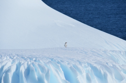
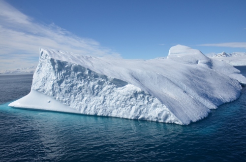
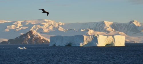
After the great whale tagging, the Explorer cruised further south along the western side of the Antarctic Peninsula, where we encountered one of the largest and most beautiful icebergs of our entire trip, and I got one of my favorite photos:

Iceberg & Bow (1024x678)

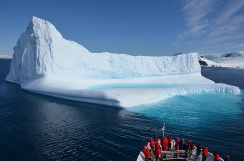
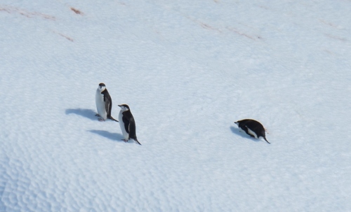
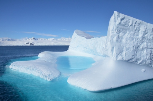
Those tiny black dots on the ice are not specks of dust on my lens, they are penguins, that’s how big this berg was!  And this berg came with its own penguin swimming pool — the beautiful blue water inside the ice.  The Explorer moved carefully around the berg, giving us a great look at the penguins (chinstraps and a Gentoo), as well a poolside perspective, where we could see one intrepid penguin making its way down for a swim.

Post Killer big berg chinstraps (1024x621)

Post Killer big berg chinstrap (1024x678)

Post Killer big berg pool (1024x678)

Post Killer back of big berg (1024x678)

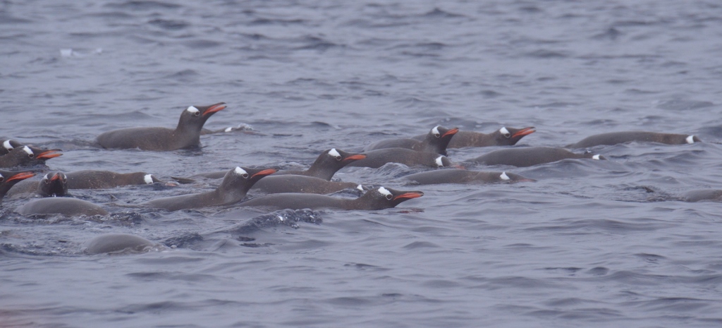
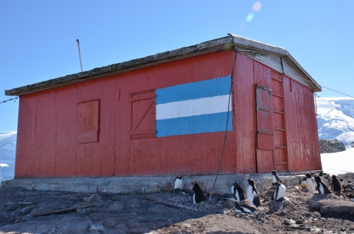
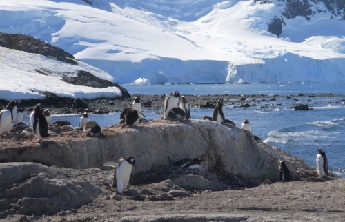
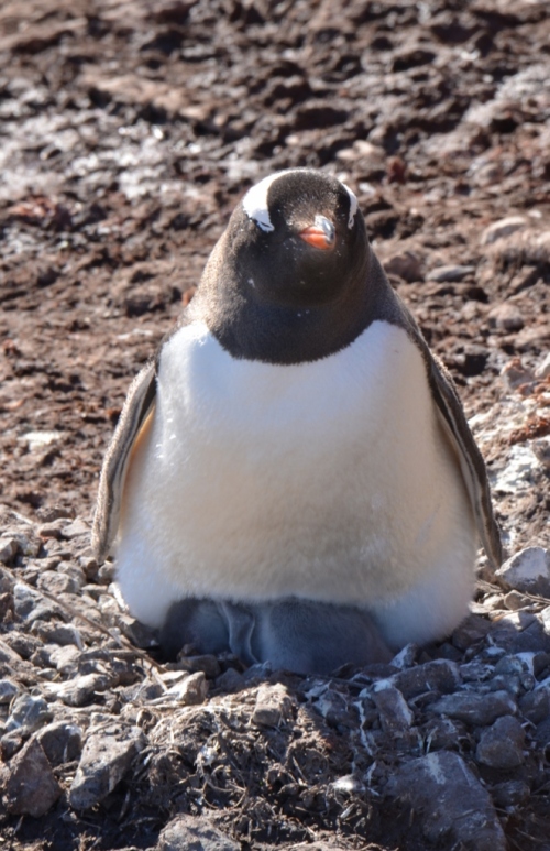
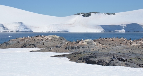
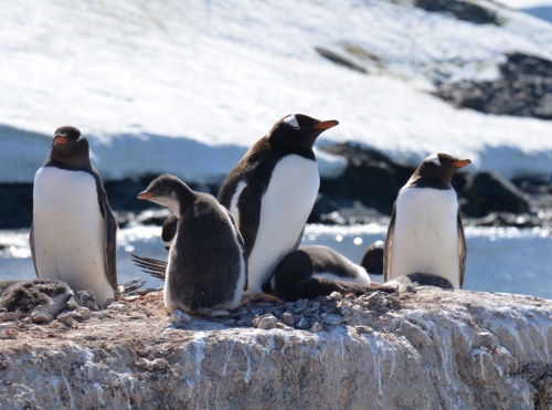
After our tour around Big Berg, we headed for Mikkelson Harbour on Trinity Island, off the western coast of the Antarctic Peninsula, the site of our second landing.   The island is home to an abandoned Argentine hut and a Gentoo rookery.  After the pristine beauty of Brown Bluff, it seemed a bit cramped, as well as incongruous, to get ashore and find penguins standing around an old building.

Mikkelson hut2 (1024x678)

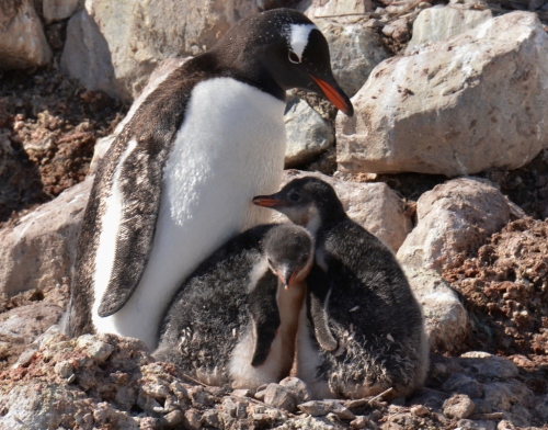
But a walk further away from the landing site on this very beautiful day gave us many good looks at the Gentoos  — who were nesting, feeding, coming and going from the sea — and the overall setting of the Harbour was certainly stunning.

Mikkelson gentoos2 (1024x661)

Gentoo chicks (1024x804)

Gentoo pair (1024x672)

Mikkelson gentoos & ship2 (1024x619)

Mikkelson gentoo on chicks (662x1024)

Mikkelson Harbour2 (1024x546)

Mikkelson rookery2 (1024x760)

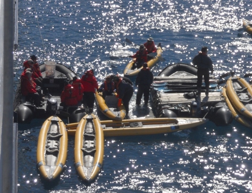
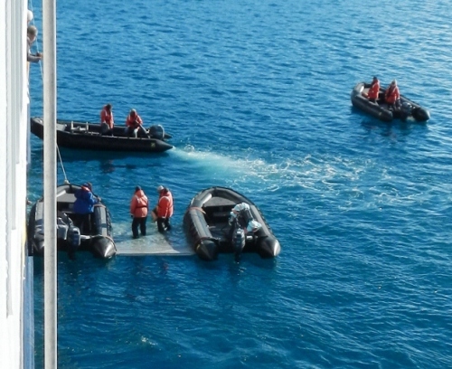
Bud had told us that we’d probably have a chance to go kayaking this afternoon, and from Trinity Island, we could see that the crew were in fact getting the ship’s two-person kayaks ready for launching.

Mikkelson Explorer & kayaks (1024x590)

Those who were interested in kayaking had already been briefed on what to expect.  MP and I have some limited kayaking experience, but MP decided to pass on this. One of our new expedition friends said she was a pretty experienced kayaker, so she and I paired up.  I’ll candidly state that while I wasn’t very worried about flipping over in the kayak, since we’d been assured it was almost impossible to do this, I was still a tiny bit apprehensive about being in a kayak in frigid waters, not to mention in waters where a whale could upend us.  But I was determined not to miss the opportunity to kayak in Antarctica, so I put my apprehension aside.

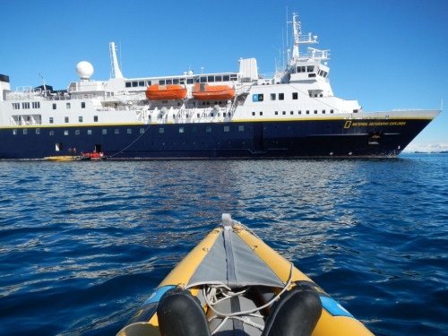
The kayaks were launched from a small platform that was set up between two zodiacs outside the zodiac boarding area.  The platform itself was slightly submerged, with the kayak sitting in the water.  It was no problem to step out onto the zodiac and then into the kayak.  (These are zodiacs coming back in, but you get the idea.)

Mikkelson kayak launch (1024x948)

Given our friend’s kayaking experience, she sat in the rear so she could steer (the kayaks had foot pedals that operated a little rudder), and I was up front.  Before we were pushed off from the zodiac boarding area, we were given instruction about steering, told where we could go and not go, and were specifically warned to stay away from the stern of the Explorer, where we could get chopped up by the ship’s propeller.  Well, without belaboring this, let’s just say that my kayaking buddy had a little bit of dyslexia with the steering, and despite our paddling furiously to correct our course, we soon found ourselves headed just where we were told not to go — the stern of the ship.   We pretty much ran right into it.  Somehow, we managed not to become sliced and diced whale food, but I think the crew are still laughing at us (and I know that MP up on deck watched all this play out in horror).  It’s a funny story now, but it was pretty scary at the time (and really embarrassing).

After we finally got clear of the ship, we paddled around, amazed that we were doing this in Antarctica, not to mention kayaking in parkas and Muck Boots.  We had great views of the surrounding ice and of the Explorer from water level.  Given our steering misadventures, though, we elected not to paddle out to the zodiac where hot chocolate was being served.  But we still had fun!

Kayaking (1024x768)

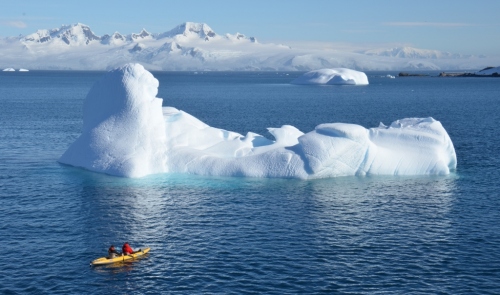
These are my actual feet. ^  And here are some folks enjoying a great view of a beautiful berg:

Mikkelson kayak & iceberg (1024x606)

By the time we’d finished kayaking, it was about 5 PM on a really long and exciting day that had started at dawn with the killer whale wake-up call.  I was, quite literally, exhausted.   I showered, put on clean and dry clothes, and was really looking forward to a little bit of down time before the evening briefing and dinner.   But no!  Just as I had stretched out on the bed, Lucho, our Assistant Expedition Leader, announced over the PA system that the Polar Plunge was going to take place in about 15 minutes, and that anyone interested in participating should get down to the Mud Room in a bathing suit.   Wow, the Polar Plunge, totally unexpected today!  And yes, we were actually being offered the chance to jump off the side of the ship into the 29° F waters of Antarctica wearing only a bathing suit!!  It doesn’t get much better than that!  🙂

When we booked this trip, I knew that the Polar Plunge was on the list of things we might be able to do, but that there were no guarantees.  I also knew going in that I was absolutely going to take the Plunge if we had the chance, just as I was equally certain that MP, who thinks that water temps in the low 70s are too chilly for swimming, would never do it, and I was right.

So while MP headed off to find a good location on deck for watching the Plungers, I put exhaustion aside and quickly changed out of my clothes into my bathing suit (brought along JUST for this purpose), put on the big terry cloth robe supplied in the cabin, and my flip flops, and headed down to the Mud Room, where there was already a line of other crazy people like me folks ready to jump into the frigid water.  With the access bays to the zodiac boarding area open, and the cold air blowing in, it was FREEZING in the Mud Room.  As far as I was concerned, the line could not move fast enough.

Mikkelson Plunge line (1024x768)

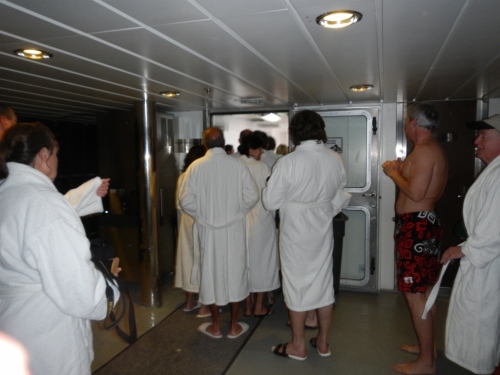
Finally, I neared the front, and noticed that the ship’s wonderful doctor (Doctor Patty as we called her) was right out there in a zodiac next to the platform (in a parka, not a bathing suit), ready to provide emergency assistance in case the Plunge stopped anyone’s heart.   Well, it was certainly comforting to see her out there!  Members of the ship’s crew were also on the platform to pull the Plungers out of the water.

Polar plunge platform (1024x855)

When it was my turn, I took off my robe and glasses, stepped onto the zodiac and out to the platform, and jumped right in.  It felt as though I were descending for a long time, although I’m sure it was only seconds.  Even before I surfaced, I was being pulled out by the crew.  Yes, the water was (almost) freezing.  Yes, it was exhilarating.   And yes, I would do it again in an instant.

As I was drying off in the Mud Room, MP rushed in and took a picture of me.  I have a great smile of joy on my face, like — can you believe that I just jumped into 29° water?   (And no, I’m not going to post a picture of myself in a bathing suit on the internet, you’ll just have to trust me that my expression was joyful.)

At dinner, we encountered many folks who had not taken the Plunge, and thought it was very brave of me to have done so.   I don’t think that at all.  I just think it was amazingly good fun, one more unique experience on this trip that I will never forget!

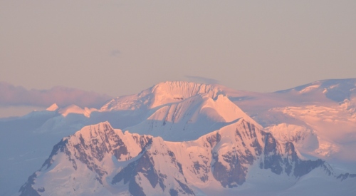
After dinner, although I was really tired, I decided to stay up for sunset, since the sky was clear.  According to our Daily Program, the sun would set at 9:35 PM.  While that may not sound like very late in the evening, the day had been packed since dawn, and very few of my fellow travelers were on deck with me as we sailed further south, with the light from the setting sun casting a wonderful glow on the continent of Antarctica.

Post Mikk Bird & Berg (1024x460)

Post Mikk setting sun on cont (1024x565)

Post Mikk sunset clouds (1024x678)

And finally . . .

Post Mikk sunset (1024x566)

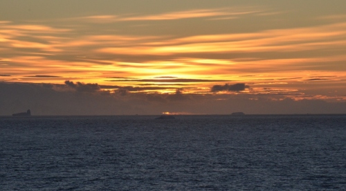
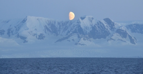
With the sun down, it was at last time to call it a day.  But when I got down to our cabin, I saw this fantastic sight out the cabin window — another reminder that the beauty of Antarctica just did not stop:

Mikkelson day moon (1024x532)

(Polar Plunge, kayaking platform, and some Mikkelson Harbour photos by MP, all other photos by turtles06)

Older Posts »

Categories